1/12


Trainsity Osaka
1K+下载次数
4.5MB大小
2.6.203(13-06-2024)最新版本
详情评价版本信息
1/12
Trainsity Osaka介绍
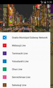
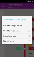
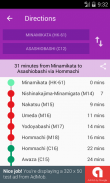
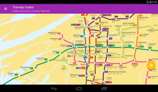
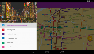
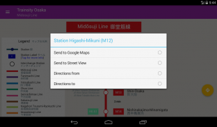
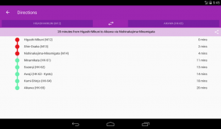
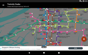
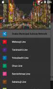
使用火车网络的高分辨率矢量地图,在大阪市的地铁中寻找路线。可以使用以下地铁路线:御堂筋,谷町,四桥,中央,千日前,Sa筋,长hor鹤见-龙口,今里筋,Newtram Nanko Port Town,北大阪急行,近铁京阪那,阪急京都,阪急千里,大阪单轨电车和北九州南北线。这些地图的文件占用空间较小,但具有多个缩放级别,可以在不连接到Internet的情况下脱机工作。用户可以单击火车站的框标签以打开Google Maps或Google StreetView,他们可以在其中使用Google应用程序的所有功能来可视化周围区域和/或执行路线导航。还有一个离线功能,可以计算出从一个站点到另一个站点的最佳旅行方式,其中包含方向细分和时间安排(可能与实际旅行时间有所不同)。
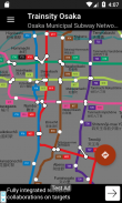
*现在具有黑暗模式设置。
保证非恶意应用此应用已通过病毒、恶意软件和其他恶意攻击的安全测试,不含任何威胁。
Trainsity Osaka - APK信息
APK版本: 2.6.203程序包: com.dom925.trainsity.osaka名称: Trainsity Osaka大小: 4.5 MB下载次数: 0版本: 2.6.203发布日期: 2024-06-13 16:25:29最小屏幕: SMALL支持的CPU:
程序包ID: com.dom925.trainsity.osakaSHA1签名: E5:9D:19:FD:8D:A4:3A:AF:CD:14:FF:7A:C8:C2:21:93:15:E5:49:67开发商 (CN): Dominic Chin组织 (O): 本地 (L): 国家/地区 (C): SG州/市 (ST): 程序包ID: com.dom925.trainsity.osakaSHA1签名: E5:9D:19:FD:8D:A4:3A:AF:CD:14:FF:7A:C8:C2:21:93:15:E5:49:67开发商 (CN): Dominic Chin组织 (O): 本地 (L): 国家/地区 (C): SG州/市 (ST):
Trainsity Osaka的最新版本
2.6.203
13/6/20240 下载次数4.5 MB 大小
其他版本
2.1.18
12/6/20180 下载次数2.5 MB 大小


同类应用


English


